|
Click on thumbnail image for a larger view |
|
|
|
|
|
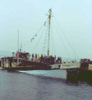
Scuttling of the Nina
T |
Nina T on
the bottom |
|
Wreckhunter.net |
Hunting New England Shipwrecks
Nina T
|
Click on thumbnail image for a larger view |
|
|
|
|
|
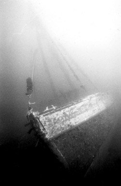
Scuttling of the Nina
T |
Nina T on
the bottom |
The table below provides historical and statistical data on the vessel. Some of the information may be incomplete. If you have additions or corrections, please e-mail us at the address listed below.
|
Shipwreck Data |
|
| Vessel Name | Nina T |
| Other Names | |
| Vessel Type | Fishing Trawler |
| Owner | |
| Length / Beam / Draft (feet) | 70' / / |
| Tonnage | |
| Hull Construction | Wood |
| Propulsion | |
| Cargo | |
| Built | |
| Date of Loss | September 1997 |
| Reason for Loss | Scuttled |
| Fatalities | |
| Location | Off Eastern Point, Gloucester, MA. The Nina T is near the Chester A. Poling (stern section). Usually there's a marker buoy on the wreck. |
| Coordinates (Lat/Lon) | 42-34.133N / 70-40.522W |
| Coordinates (Loran C) | |
| Water Depth (feet) | 100' |
| Typical Visibility (feet) | |
| Wreck Condition | Intact and upright. In 2002, divers reported that the wreck is beginning to disintegrate. |
| Diving Considerations | |
| Other Information | |
Attention Divers The information on this page was obtained from a variety of sources. Although we have attempted to make it as accurate as possible, it may contain errors. For your personal safety, use extreme caution when diving on this wreck. For more information on this wreck's location and history, and water and diving conditions in the area, contact local dive shop personnel, dive charter boat operators and local fishermen. Also check out the other shipwreck Websites listed on our Favorite Links page.
To go to other pages on this site, use the Site Navigator at left, or click here to go to our Home Page.
Comments or questions
editor@wreckhunter.net
Copyright © 2001 by Dave
Clancy
All Rights Reserved