|
Click on thumbnail image for a larger view |
|
|
|
|
|
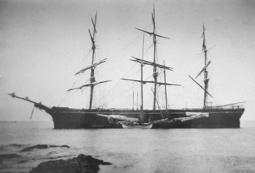
Lydia Skolfield |
|
|
Wreckhunter.net |
Hunting New England Shipwrecks
Lydia Skolfield
|
Click on thumbnail image for a larger view |
|
|
|
|
|
Lydia Skolfield |
|
The table below provides historical and statistical data on the vessel. Some of the information may be incomplete. If you have additions or corrections, please e-mail us at the address listed below.
|
Shipwreck Data |
|
| Vessel Name | Lydia Skolfield |
| Other Names | |
| Vessel Type | Square-rigged ship |
| Owner | |
| Length / Beam / Draft (feet) | |
| Tonnage | |
| Hull Construction | Wood |
| Propulsion | Sails |
| Cargo | Cottonseed oil |
| Built | |
| Date of Loss | April 19, 1891 |
| Reason for Loss | Grounded in fog |
| Fatalities | None |
| Location | Newport, RI, off Bateman's Beach, just east of Butter Ball Rock |
| Coordinates (Lat/Lon) | 41-27-31N / 71-21-41W |
| Coordinates (Loran C) | |
| Water Depth (feet) | 30' Maximum |
| Typical Visibility (feet) | 10' |
| Wreck Condition | Only small objects remain, wedged between rocks |
| Diving Considerations | Strong current area |
| Other Information | |
Attention Divers The information on this page was obtained from a variety of sources. Although we have attempted to make it as accurate as possible, it may contain errors. For your personal safety, use extreme caution when diving on this wreck. For more information on this wreck's location and history, and water and diving conditions in the area, contact local dive shop personnel, dive charter boat operators and local fishermen. Also check out the other shipwreck Websites listed on our Favorite Links page.
To go to other pages on this site, use the Site Navigator at left, or click here to go to our Home Page.
Comments or questions
editor@wreckhunter.net
Copyright © 2001 by Dave
Clancy
All Rights Reserved