|
Click on thumbnail image for a larger view |
|
|
|
|
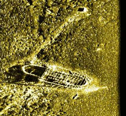
| Horse
Ferry sonar image (Garry Kozak/ Klein Assocs.) |
|
|
Wreckhunter.net |
Hunting New England Shipwrecks
Horse Ferry
|
Click on thumbnail image for a larger view |
|
|
|
|
| Horse
Ferry sonar image (Garry Kozak/ Klein Assocs.) |
|
The table below provides historical and statistical data on the vessel. Some of the information may be incomplete. If you have additions or corrections, please e-mail us at the address listed below.
|
Shipwreck Data |
|
| Vessel Name | Horse Ferry (real name unknown) |
| Other Names | |
| Vessel Type | Horse-powered ferry |
| Owner | |
| Length / Beam / Draft (feet) | 63' / 23'/ / |
| Tonnage | |
| Hull Construction | Wood |
| Propulsion | Horse-driven turntable / Side-wheels |
| Cargo | |
| Built | |
| Date of Loss | |
| Reason for Loss | |
| Fatalities | |
| Location | Lake Champlain, northwest of the Burlington (VT) breakwater, approximately 2/3 of the way to Lone Rock Point. |
| Coordinates (Lat/Lon) | 44-29.1N / 73-14.6W |
| Coordinates (Loran C) | |
| Water Depth (feet) | 50' |
| Typical Visibility (feet) | Usually poor |
| Wreck Condition | Partially intact |
| Diving Considerations | A permit is required to dive this wreck. |
| Other Information | For
more information on the Horse Ferry, Click
Here. Lake Champlain Underwater Historic Preserve - Info & Wreck Map |
Attention Divers The information on this page was obtained from a variety of sources. Although we have attempted to make it as accurate as possible, it may contain errors. For your personal safety, use extreme caution when diving on this wreck. For more information on this wreck's location and history, and water and diving conditions in the area, contact local dive shop personnel, dive charter boat operators and local fishermen. Also check out the other shipwreck Websites listed on our Favorite Links page.
To go to other pages on this site, use the Site Navigator at left, or click here to go to our Home Page.
Questions or comments?
editor@wreckhunter.netCopyright © 2001 by Dave Clancy
All Rights Reserved